Abstract
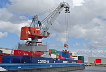
To ensure load unloads of deep-draft vessels the Matarbari port is essential for Bangladesh and adjacent countries and areas. The Matarbari deep sea port has a 16m depth that will help 16m draft vessels to unload their cargo at the terminal. At deep-sea, currently, mother vessels unload the cargo at feeder’s vessel and they carry the cargo to the Chittagong port. The present seaports (Chattagram seaport and Mongla seaport) of the country cannot handle huge containers and vessels and the building of a deep seaport is the only solution. Chittagong port can’t load-unload from more than 9.5-meter vessels.
Keywords: The Matarbari deep sea port,
Introduction
The channel built for the Matarbari coal-fired power plant would extend to the sea by deepening it so that 16-meter-draft vessels with 8,000 TEU container capacity could berth. The country’s first deep-sea port at Matarbari, the Matarbari deep sea port will follow models on the Japanese ports of Kashima and Niigata and a feasibility study of the proposed port has already completed, said CPA chairperson Commodore Zulfiqur Aziz. The government is planning to build a deep seaport in Matarbari, Cox’s Bazar, by using a facility of the Matarbari coal-fired power plant. The deep seaport will have a draft of 16 meters, where 350-meter-long vessels with a capacity of 8,000 TEU containers will berth—this is double the capacity of the Chittagong Port. At present, 190-metre-long and 9.5-meter-draft vessels can berth at the country’s premier port, which can handle 3,500–3,800 TEU containers.
Forecast
It is forecasted that, the existing container handling would rise from 5.7 million TEUs to 6.5 million TEUs and the number of vessels would reach 8,200. The present seaports (Chittagong seaport and Mongla seaport) of the country cannot handle huge containers and vessels and the building of a deep seaport is the only solution. Japan will give most of the required amount as a loan. Bangladesh government and the CPA will pay balance payment. This is an enterprise of the Bangladesh Naval Transportation ministry and would be completed by 2026. There would be two terminals in the Matarbari deep sea port with road communication which would help big ships load and unload easily. The design and layout are Japanese designers made the design and layout. The Japanese organization involved is JICA.
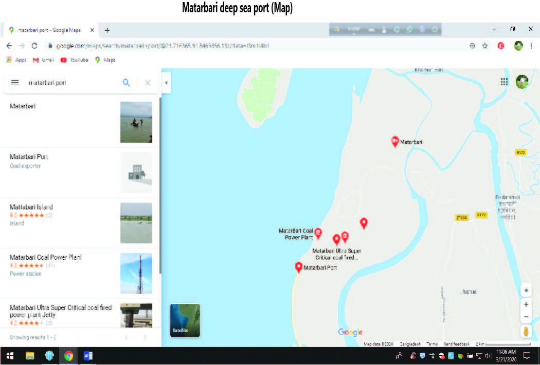
Why Matarbari deep sea port?
The Matarbari deep sea port is because other Bangladesh seaports i.e., Chittagong and Mongla port are not deep seaports. To ensure load-unload of deep-draft vessels the Matarbari port is essential for Bangladesh and adjacent countries and areas. Chittagong port can’t load-unload from over 9.5-meter vessels. A deep-sea, currently mother vessels unload the cargo at the feeder’s vessel and they carry the cargo to the Chittagong port. It is very costly. The Matarbari deep seaport has a 16m depth that will help 16m draft vessels to unload their cargo at the terminal. It will increase our country’s cargo handling capacity cost-effectively. A 28-kilometer road will add to communicate well with the port including 17 ports. It will enhance the supply chain management of the adjacent areas.
The Bay of Bengal and surrounding rivers
The Bay of Bengal is the largest bay in the world and lies in the northeastern part of the Indian Ocean. It is situated between the Indian subcontinent and the Indochinese peninsula, just south of the Bengal region. This bay plays a crucial role for several South Asian and Southeast Asian countries. Geopolitically, it is bordered to the west and northwest by India, to the north by Bangladesh, and to the east by Myanmar and the Andaman and Nicobar Islands of India. Its southern boundary stretches from Sangaman Kanda in Sri Lanka to the northwestern tip of Sumatra in Indonesia. The Bay of Bengal is home to notable landmarks such as Cox’s Bazar, which boasts the longest sea beach in the world, and the Sundarbans, the largest mangrove forest and a key habitat for the Bengal tiger. Covering an area of 2.6 million square kilometers (1 million square miles), the Bay of Bengal is fed by several major rivers. These include the Ganges–Hooghly, the Padma, the Brahmaputra–Jamuna, the Barak–Surma–Meghna, the Irrawaddy, the Godavari, the Mahanadi, the Brahmani, the Baitarani, the Krishna, and the Kaveri.
Reconnecting Bay of Bengal
The Matarbari deep seaport can be a milestone to reconnect the Bay of Bengal with surrounding areas of Asia. Sea linked before the countries like Myanmar, Bengal, Srilanka. But the creation of sovereign states such as Myanmar, Bangladesh, India, and Srilanka set impediments between the Bay of Bengal and surrounding states. Border disputes also helped to isolate the Bay of Bengal from Japan, China, India, and Myanmar. New conditions created by Matarbari deep seaport will help to develop the global supply chain and value chain.
Bangladesh is a riverine country
Bangladesh is located in South Asia with a coastline of 580 km on the northern littoral of the Bay of Bengal. The delta plain of the Ganges (Padma), Brahmaputra (Jamuna), and Meghna Rivers and their tributaries occupy 79 percent of the country. Port of Chittagong is located in Chattogram i.e, directed by Chittagong Port Authority. Port of Mongla is located in Mongla, Khulna directed by Mongla Port Authority. These two ports are major ports. Port of Payra is located in Patuakhali, Barishal directed by Payra Port Authority. These are all active ports although Payra port is compatively small. Matarbari Port is under construction and deepest port directed by Chittagong port authority.
Conclusion
For South Asia, especially the sub-region of Bangladesh, Bhutan, India, and Nepal (BBIN), enhanced connectivity over land, air, and sea can bring about a sea change in the region’s socio-economic growth potentials. Against this backdrop, diversification of communication and logistic infrastructures like building an additional seaport in the country’s coastal belt will undoubtedly cushion a load of additional cargoes via Bangladesh and make the transit-cum-trans-shipment arrangements more viable and cost-effective. Bangladesh currently boasts of three seaports, of which Chattagram Port alone caters to around 92 percent of the country’s trade cargo via the Bay of Bengal. Of these, Mongla has witnessed a gradual growth over the past 10 years, currently accounting for about 7.0 percent of the sea-borne cargo, while Payra is still in a preparatory stage with some question marks regarding its long-term viability. Land-locked Nepal and Bhutan as well as the north-eastern states of India would get a huge fillip in logistics and connectivity if they could use the sea routes via Bangladeshi seaports. With the Japanese International Cooperation Agency (JICA) funding Tk 132.53 billion out of the total estimated project cost of Tk 185.80 billion, the void of a deep seaport is poised to be filled by 2026.
Further reading:
1.http://drrgateway.net/information-communications-technology/reconnecting-bay-of-bengal
2. http://www.theindependentbd.com/post/146127
4.https://www.google.com/maps/search/matherbari+deep+sea+port/
5.https://youtu.be/2Q6zCTlW9nE?si=Kyc4BXrCSYWCciym